New release Garmin Mobile 5.00.60 for PC is updating previous version of Garmin mobile PC. Garmin Mobile 5.00.60 was released at the end of December 2008. Garmin mobile PC like garmin mobile XT that installed on your PC, practically it more comfortable if installed on small notebook. Garmin Mobile PC give Garmin Mobile XT user new experience, larger screen help user easily see map and details.
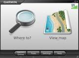
Garmin Mobile PC has same features as Garmin Mobile XT, e.g “Where to?” and “View map” interface found on the Garmin nüvi® and StreetPilot®. The difference is you must use mouse to navigate with Garmin Mobile PC. With a few clicks, customers can quickly search and route to addresses and points of interest like restaurants, hotels, attractions, gas stations and more.
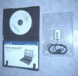
Garmin Mobile PC is available in two configurations – a software only package and a bundle with software and Garmin’s new GPS 20x sensor. The software only version is compatible with broadband modems, as well as internal or third-party GPS receivers that provide the industry standard NMEA GPS data via serial or Bluetooth connections. The bundled version includes the new GPS 20x, a high sensitivity GPS sensor with a USB connection. The lightweight GPS 20x has non-skid pads for dash mounting and is less than two inches in length.
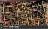
Garmin Mobile PC offers much more than traditional trip planning. Users can use their laptop to receive turn-by-turn, voice-prompted directions to their destination, similar to Garmin’s traditional portable navigation devices. If a turn is missed along the way, Garmin Mobile PC will automatically recalculate the route and get them back on track.
Garmin Mobile PC has route shaping feature, users can select specific roads they want to travel and customize their route to avoid certain roads and geographic areas. Garmin Mobile PC also enhanced with the track log feature and see an electronic bread crumb trail that shows exactly where they traveled. Garmin Mobile PC also includes a trip computer automatically records trip data.
You must consider battery life when using Garmin Mobile PC on your travel. Perhaps you should prepare Car charger for your notebook, or you may buy portable inverter DC to AC on your car that can be plugged on ciggarete lighter's plug.
Ver. 5.00.60, as of Dec 30, 2008 (Download if you have previous version)
Download: klik here...
Direct Download download...
Change History
Changes made from version 5.00.50 to 5.00.60:
* Provide highlight on the first item in the address list by default when using address wizard.
* Add new saved location to recently found list after edits are completed.
* Correct intersection search capability.
* Correct safety camera capability.
* Correct various software errors that could cause application to shutdown.
* Correct route overview fields after adding via points.
Changes made from version 5.00.30 to 5.00.50:
* Update GPS connection processing for some third party GPS drivers.
* Update COM port searches and display listings.
* Correct the display of the last selection in Fuel Prices if viewed after a Sort is completed.
* Correct the product key entry processing when not connected to the Internet.
* Correct default button highlighting when viewing nearby airports and Contacts.
* Correct default button highlighting when paging up/down on some list fields.
* Correct default button highlighting within address wizard.
* Correct distance display for airports that are thousands of miles away.
* Correct reorder via page to display numbers correctly.
* Correct application error when displaying detour by turns page before having a GPS position.
* Correct default button highlighting when returning to the Main Menu page.
* Correct application error when selecting point information in the Browse Map page.
Changes made from version 5.00.20 to 5.00.30:
* Update the product key text to warn users that the product key can only be used on one computer.
* Update the default vehicle icon to the blue car.
* Correct the color of the satellites on the satellite view page.
* Correct the application resume process to restart the trip odometer after PC sleep mode.
Changes made from version 5.00.10 to 5.00.20:
* Provide a new Setting (Settings -> Display) to override the system power settings when the application display is not minimized.
* Update the saved track line colors.
* Correct the application exit process when exiting from pages other than the Main Menu.
* Correct a rare application shutdown that could occur if GO/More is selected after clearing the recent finds list.
* Correct an error that would allow a map to be deleted without user confirmation.
* Correct the restart of the USB GPS receiver connection when a PC comes out of standby.
* Correct a rare application shutdown that could occur if a create new route is completed after deleting a route.
Changes made from version 5.00.00 to 5.00.10:
* Provide British English, French, Italian, German and Spanish text options.
* Provide ability to use the mouse scroll wheel when viewing the Help pages.
* Provide additional checksum processing of NMEA data when using third party GPS receivers to discard invalid packets coming from the receiver.
* Display the actual contact name saved when user requests to save a point as a contact.
* Correct the display of an edit button when no saved routes are available for edit.
* Correct the placement of the Next button within the address wizard.
* Correct an error that sometimes causes the application to display the wrong page after adding a via to a route.
* Correct the track line display for active tracks to not offset the track from the traveled road.
* Correct the update of the POI list when the user changes the Near Other criteria.
* Correct a texture shade drawing issue that would sometimes incorrectly draw the map relief shade textures.
* Correct the Recent Finds list to only display the address once for locations found via the Browse Map page.
* Correct the filter clear processing for Categories and Symbols for Contacts.
* Correct the displayed name for a new saved Favorite.
* Correct the display of saved route details after an edit of the details is complete.
* Correct an error that causes an application shutdown when a Safety Camera file is downloaded from the server.
* Correct the display of the Custom POI file names within Manage My Data.
* Correct the display of the Custom POI file names when routing to a Custom POI.
* Correct a rare error that could cause an application shutdown when a route is imported from MapSource to Garmin Mobile PC.
* Correct the application exit process when exiting from pages other than the Main Menu.
* Correct the display of saved Contacts names in the Contacts list.
* Correct the scroll bar display on the address detail page.
* Correct the scroll bar display on the Saved Route list.
* Correct the scroll bar display on the Tools page.
* Correct the scroll bar display for the Near Other radio button page.
* Correct an error that causes an application shutdown when two or more vias are added to a route.
* Correct an issue where a message box is overwritten by other displayed text.
* Correct the Garmin Online Subscription Status page to always update the subscriptions when accessing this page.
Installation Instructions
1. As with any software update, you should always create a backup of the data on your device before beginning. Please see the information provided in the user manual for your PC for more information.
2. Close all open applications on your device including Garmin Mobile PC.
3. Select the 'Download' link found on this web page.
4. Select to 'Run' or 'Save' the file. Selecting 'Run' will immediately launch the install program. Selecting 'Save' will save the file to your PC and require you to launch the install program from the saved location.
5. Follow the directions provided when running the downloaded program to complete the application update.
6. After completing these steps, verify the update was successful by going to Settings -> About within the Garmin Mobile PC application and viewing the updated version number.
System requirements
1. IBM-compatible PC running Windows 2000 or later operating system.
Review:
- http://www.laptopgpsworld.com/garmin-mobile-pc/432-review-garmin-mobile-pc.html
- http://www.laptopmag.com/review/software/garmin-mobile-pc.aspx
- http://www.pcmag.com/article2/0,2817,2336529,00.asp
Comments